Mapping Sub-Saharan Africa to Enable Life-saving Humanitarian Aid
As part of our commitment to using AI for good, we partnered with several humanitarian organizations to build the first comprehensive map of Sub-Saharan Africa.
-
Date 06/22/2023
-
Partnership Maxar
-
Topic AI for Good
-
Product Global Feature Extraction
Client
Mapping Communities in Need to More Efficiently Distribute Humanitarian Aid
Humanitarian organizations perform some of the world’s most important work - but also some of the most challenging. The World Bank estimates that roughly 8.6% of the global population live in poverty and struggle to meet basic needs related to food, shelter, and healthcare. That’s about 688 million people, many of whom are in need of humanitarian aid.
Many organizations have partnered together to try to help improve public health in Sub-Saharan Africa by supporting increased access to quality and affordable healthcare for underserved populations. These humanitarian partner organizations are working to expand the availability of life-saving prevention and care for diseases such as yellow fever, malaria, polio, and Ebola. Great improvements in public health have been made through these efforts. For example, in less than a decade, malaria deaths in Nigeria have declined by 75%.
However, mapping experts at these organizations knew that limitations in geospatial data coverage for Sub-Saharan Africa were impeding their abilities to reach every community in need. Unlike those in other regions of the world, most countries in Sub-Saharan Africa do not have comprehensive mapping applications for humanitarian organizations to use in their field planning. As a result, many local teams were using hand-drawn maps of settlements to plan their routes and delivery schedules for vaccines and other medical supplies.
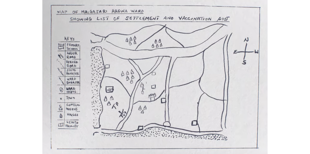
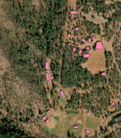
To understand the accuracy of available map data, these partner organizations tested the maps like the one above by driving to various settlements in northern Nigeria and collecting GPS coordinates. They then compared these coordinates to the hand-drawn maps, quickly realizing most buildings were represented in the wrong locations, and some were left out altogether.
Not only did the hand-drawn maps not match the GPS coordinates that were captured in the field, but teams knew that they hadn’t even visited every community and thus were unable to map them. “We knew vulnerable populations were being missed, but there was no way to reach them without a complete and up-to-date map,” said Vince Seaman, Senior Program Officer on the Polio Team at the Bill & Melinda Gates Foundation, one of the team members working on the project.
Buildings are a critical component to health and humanitarian mapping operations, as they indicate where workers should go to distribute care and help them determine the most efficient routes. With a comprehensive map of buildings, geographic information systems (GIS) teams can estimate the population of different settlements, enabling them to quantify the supplies needed for each settlement. They can also optimize their routes and reduce the amount of carbon emissions produced driving between settlements.
While satellite imagery data did exist for the areas organizations needed maps for, it was not actionable without being digitized into vector features for geospatial analysis (for example, mapping all buildings). Manually digitizing features is a time-consuming and tedious process, and difficult to do at scale for large areas like Sub-Saharan Africa. The World Health Organization (WHO) has held various map-a-thons calling on the international geospatial community to digitize buildings in the region, but found that even with hundreds of people mapping for multiple days, only about one million building points were generated, just a fraction of the estimated 416M+ in Sub-Saharan Africa. Similar initiatives have been sponsored by HOT OSM, but take months to manually digitize individual features at a large scale. Furthermore, building points are not as helpful for population estimates as they do not indicate the size of each structure.
To help address this problem, the Gates Foundation awarded a series of grants to partners who could develop complete nationwide building maps for countries where partner organizations had operations but insufficient data. The partners worked with various geospatial data providers to extract building vector features from satellite imagery data, but found that it was expensive and took about a year to digitize one single country. “This process was not scalable or sustainable,” continued Seaman. “Mapping one country a year was too slow, and meant our data quickly became stale. The world changes fast, populations migrate, and partners need maps that are kept up-to-date so they can best plan field work and reach everyone in need.”

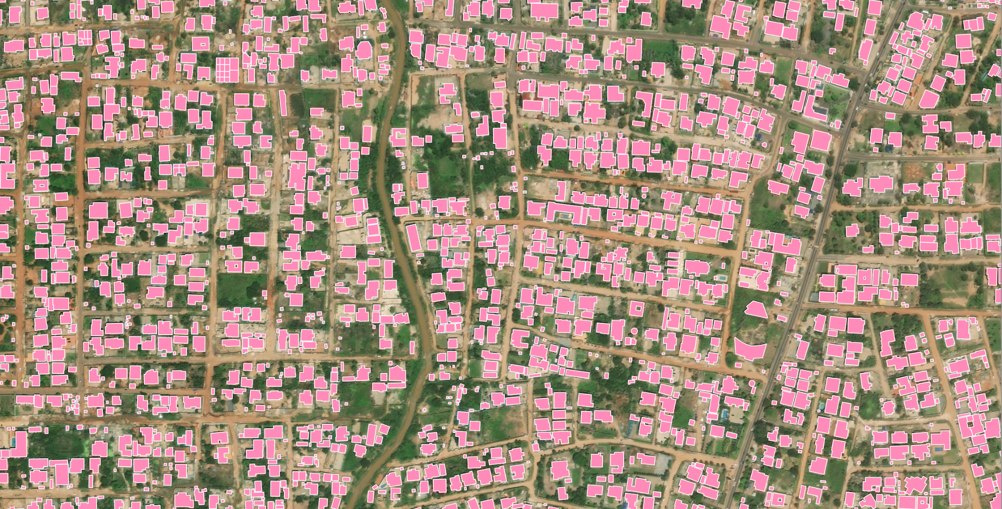
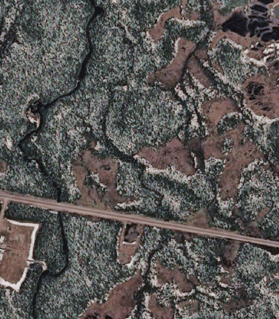
An example of input satellite imagery and Ecopia’s output building footprint data in Kenya, demonstrating how vectors are more actionable for humanitarian organizations than imagery alone
Digitizing Sub-Saharan Africa with Ecopia’s AI-Based Mapping Systems
Ecopia AI (Ecopia) had extensive experience mapping buildings, having extracted every building in both Australia and the United States. Each initiative took only six months, demonstrating that artificial intelligence (AI)-based mapping technology could be used to rapidly scale feature digitization without sacrificing the level of detail needed for optimizing humanitarian resources. Ecopia achieves this by ingesting geospatial imagery from an extensive global partner network, including Maxar Technologies.
Through this partnership network, the Gates Foundation became aware of Ecopia’s plans for an initiative called Digitize Africa, supported by funding from Sustainable Development Technology Canada (SDTC). Digitize Africa sought to leverage Ecopia’s artificial intelligence and satellite imagery from Maxar to digitize every building and road in 51 African countries. While manual digitization at this scale would take an estimated 7,500 years to complete, Ecopia was able to map all 416 million buildings and 17M kilometers of roads in just eight months.
“SDTC is proud to fund Ecopia’s Digitize Africa program to help provide high quality geospatial data that saves and improves the lives of millions, while reducing carbon emissions by optimizing travel routes for humanitarian activities,” said Leah Lawrence, President and CEO of SDTC. “These building footprints also lay the foundation for future sustainable innovation across Sub-Saharan Africa, including identifying ideal locations for solar energy and other renewable energy sources. There are many ways geospatial data can have a positive impact on the region that would not be possible without Ecopia’s building footprint data, and we are thrilled to support this initiative.”
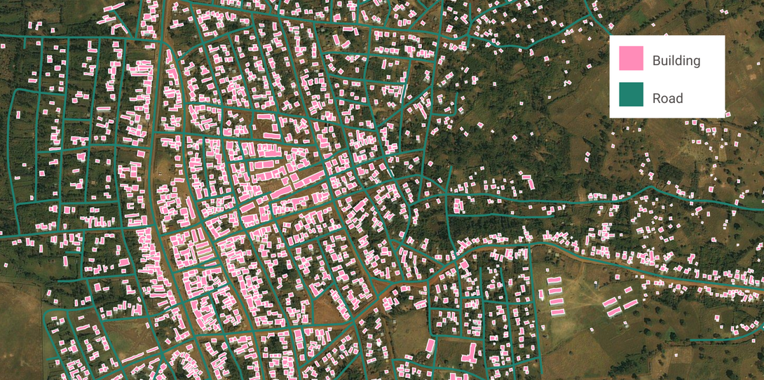
With the comprehensive, accurate, and up-to-date map of buildings and roads in Sub-Saharan Africa, humanitarian organizations are developing more efficient delivery plans. Aid workers can now easily visualize where communities in need are, estimate how many people need care, and determine the best routes between settlements. This ultimately saves time and resources while also reducing harmful CO2 emissions generated by inefficient routes.
Most importantly, with the maps provided by Ecopia, field crews can be sure they are not missing any settlements. Stephane Vouillamoz, Executive Director and Co-Founder of Novel-T, an engineering firm working to implement the data, noted that when using incomplete maps for planning, there were inevitably chronically-missed communities. “With Ecopia data, we were able to identify thousands of people in settlements we did not know existed, and develop field plans that would give them the medical care they need,” Vouillamoz said.
Among Novel-T’s contributions to the humanitarian effort is the development of a passive tracking system. Using geospatial applications powered by Ecopia’s building footprint data, the system automatically tracks where field crews have distributed aid, meaning organizations do not need to train their workers on how to collect coordinates and make a map. Instead, they can focus on providing critical medical services.
“Ecopia’s ability to map every building and road in Sub-Saharan Africa enables us to save and improve the lives of millions,” added Ravi Shankar, Head of GIS at the WHO. “This data is an absolute game-changer for the WHO and other humanitarian organizations as we conduct field work. Ecopia is one of the best datasets we could have.”
The data provided by Ecopia has helped many humanitarian organizations to optimize their planning and reach more people in need. Through Ecopia’s commitment to using AI for good, the data was made available to humanitarian groups distributing life-saving medical care throughout the region. For example, the Red Cross has leveraged Ecopia building footprint and road data to distribute bed nets for antimalarial initiatives. Similarly, the WHO has created catchment areas for snake bite treatment centers to make sure settlements are within a reasonable distance to receive care. Catchment analysis has also proven helpful in combating the spread of Ebola, as defining a radius around an outbreak can help humanitarian crews distribute limited resources effectively.
Continuing to Develop AI-Based Mapping Solutions in Sub-Saharan Africa
Ecopia’s creation of a reliable map of Sub-Saharan Africa has sparked further geospatial innovation in the region. The WHO Afro-GIS Centre in Brazzaville, Republic of Congo, is building a culture of GIS, enabling its workers and partners with the latest mapping advancements and promoting geospatial literacy. “Our teams in Africa are trained to use the Ecopia data for ‘what-if’ scenarios, greatly improving our preparation for possible health crises,” continued Shankar. “In the past, healthcare facilities were placed in a location by chance, not by choice. With Ecopia data, we can determine accessibility to critical medical services and select sites for new care centers.”
Other organizations dedicated to advancing GIS in the region have since been formed. In 2018, GRID3 was founded through a partnership of Columbia University’s Center for International Earth Science Information Network (CIESIN), WorldPop at the University of Southampton, the Flowminder Foundation, and the United Nations Population Fund (UNFPA). GRID3’s goal is to help governments in Sub-Saharan Africa make full use of spatial data to solve their most pressing development challenges, and the team has been working closely with the Gates Foundation, WHO, Novel-T, and other partner organizations to involve governments in the generation, validation, and use of foundational geospatial data products on population, settlements, infrastructure, and boundaries.
“Before Ecopia, it was difficult to map all settled areas in the region and accurately allocate population to where people reside” said Olena Borkovska, GRID3 Project Coordinator at CIESIN. “We founded GRID3 to put everyone on the map and empower governments with accurate and up-to-date data. Ecopia is a key component of that.”
Among the many responsibilities of GRID3 is annotating the Ecopia maps with population estimates, settlement names, and nearby points of interest. This added context is helpful for field crews and government aid groups as they plan public health services and conduct field visits to distribute care.
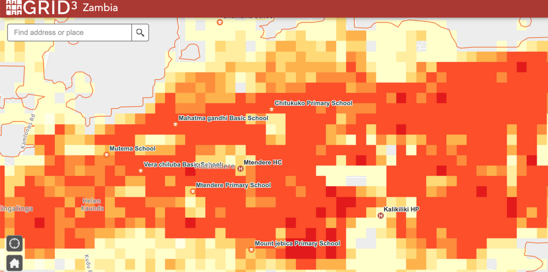
For example, GRID3 is working with the Government of Zambia to support planning of bed net distribution throughout the country, part of the government’s goal of eliminating malaria. An accurate population estimate is required to source enough nets and make sure no community is missed, but at the time of 2020 and 2021 malaria campaigns, the most recent census in Zambia dated back to 2010. Data from Ecopia is a crucial component of GRID3’s population modeling that provides estimates of how many people currently live in Zambia, and how that population is distributed throughout the country.
“The foundational building footprints and roads provided by Ecopia combined with the annotations by GRID3 are transforming the way partners make maps and plan activities,” said Seaman. “Our goal at the Gates Foundation is to improve healthcare for underserved communities, and our ability to help provide governments and partners with tools to better reach remote settlements and populations has dramatically increased with more comprehensive and detailed maps.”
Building a Healthier Future with Better Maps
The data created through Ecopia’s Digitize Africa program is driving innovation and equity in Sub-Saharan African humanitarian aid. While the initial goal of the project has been met - creating reliable mapping data in the region to use in field planning - the various organizations involved know that there are endless opportunities for building upon the data and improving more lives.“There are so many ways this critical data can be applied to help people,” continued Borkovska. “Besides the use of the data in the health sector, GRID3 has worked with stakeholders in the education and development sectors to identify populations without access to critical services, and ultimately make the data even more accessible to make a difference.”
Ecopia and the humanitarian organizations involved in Digitize Africa are currently exploring ways to enhance the data and expand its usage to other important applications. Since the data was mapped, people have inevitably moved and settlements have changed. Additionally, technological advancements have been made in GIS that could provide even more insights into populations in need. For example, geospatial imagery is now available at even higher resolutions, and Ecopia has begun mapping the world in 3D - two innovations which could result in an even more detailed map of Sub-Saharan Africa.
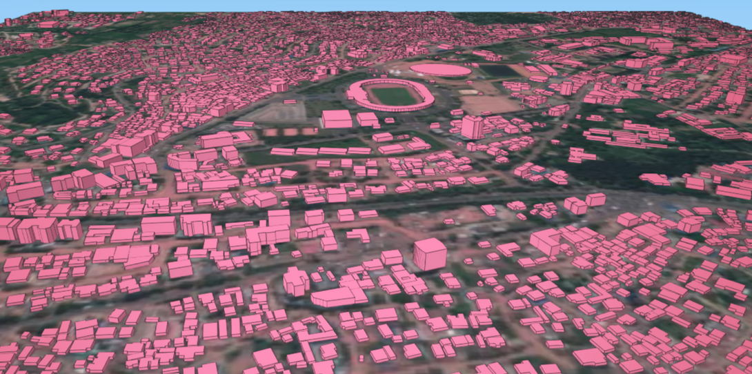
“3D building maps are the future of population estimation,” said Vouillamoz. “As Novel-T continues to work with humanitarian organizations on public health issues, understanding how tall a building is will be critical to estimating how many people need care in a settlement.”
In Ghana, the WHO is conducting a door-to-door survey using Ecopia building footprint data to understand malnutrition and plan future work. “Having a reliable map of every building helps us reach everyone and collect all of the household-level data we need to distribute aid,” said Shankar. “There is no way to truly know where the next public health crisis will be, but having this type of data on a global scale would help the WHO respond more efficiently and save more lives.”
The population and property insights derived from building footprint data are also driving innovation in sustainability throughout Sub-Saharan Africa. Understanding where people live and how population density changes over time is an essential input to selecting new locations for renewable energy power plants, identifying ideal sites for solar panels, and other green infrastructure projects. Overall, the availability of accurate, comprehensive, and up-to-date geospatial data is helping people in the region lead healthier lives and develop more sustainable communities.
“We founded Ecopia to develop geospatial solutions for the world’s most pressing challenges, and are proud to empower humanitarian organizations with actionable data,” said Jon Lipinski, President and Co-Founder of Ecopia. “Ecopia will continue our work with these groups to further enable them to do good around the world.”
Ecopia is committed to using AI for good and enabling organizations to save lives with high quality mapping data. To learn more about Ecopia’s work with NGOs, click here.
This work was supported from 2019-2021 by a contract from the Bill & Melinda Gates Foundation of US $5,000,000 and a contract of CA $6,670,000 from Sustainable Development Technology Canada.
Learn more about Ecopia's mission to use AI for Good
Blog
AI for Good
Providing Open Mapping Data to Help Responders After the Beirut, Lebanon Explosion
News
Network Planning
State of Arizona Expands Rural Broadband Access with Ecopia Data
News
Network Planning
Ecopia AI Awarded Contract from Canadian Government to Support Rural Broadband Mapping Across the Country
Ready to get started?
If you're ready to leverage groundbreaking advancements in artificial intelligence, let's chat.